[Editor’s note: The following post is intended as a public service for readers in the Los Angeles region — and for CPR Initiative supporters who may be in touch with loved ones living there.]
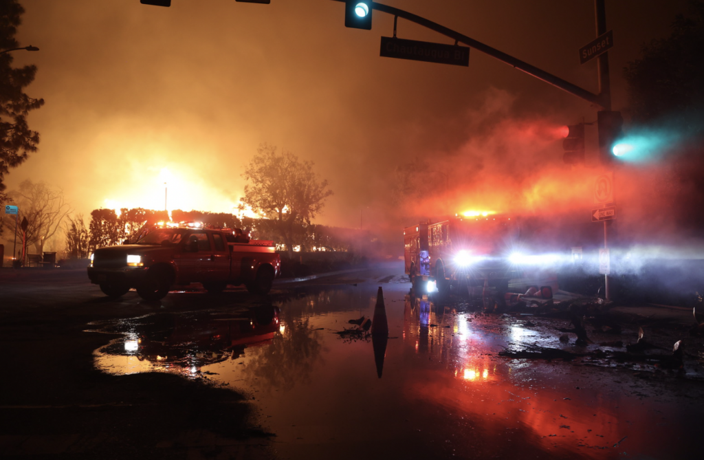
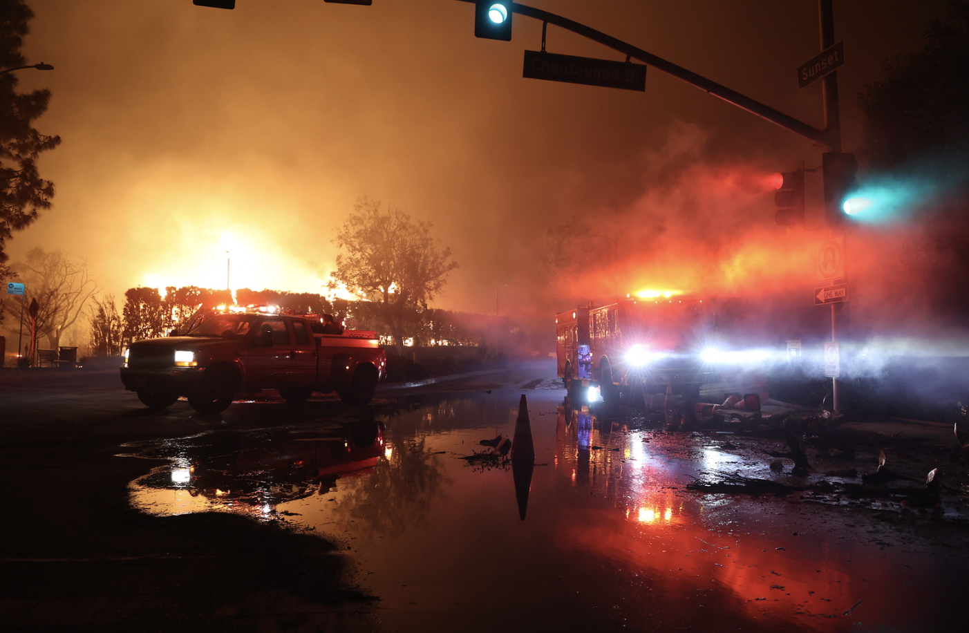
At this writing, at least five uncontrolled wildfires are visiting destruction across Los Angeles from end to end. Many homes, entire neighborhoods, commerce, dreams, and at least five lives are now just “gone,” to appropriate Terra Mahadevan’s words in her special note published below.
To a one, these fires were stoked by merciless, 100mph “Santa Ana” winds — easterly winds that billow west from the Great Basin, crossing parched desert lands before barreling down foothills. The winds gained heat from atmospheric compression as they descended into Los Angeles. This one hit Tuesday, a veritable hurricane of dry heat inducing firestorms.
If you are in LA and subject to a verified evacuation order,1Regrettably, at 4pm pacific yesterday, January 9, an evacuation order earmarked for Hidden Hills residents near the Kenneth Fire (just north of the 101) was mistakenly sent to residents all across Los Angeles County. But the overwhelming majority of evacuation orders that have been issued across the county have been accurate and life-saving.we urge you to do what local authorities are urging. And without delay. That is, to go. And if someone you know is subject to such an evacuation order, we hope you will help them to get to safety without delay.
If it is you, or a loved one, do not delay: head to safety, now.
Fossil fuel emissions accumulating in the atmosphere have contributed mightily to this still-developing inferno, but analytical dissection will not help you now, nor will it aid those you care about, if you are now in its path. Again, as warranted, figure out your escape route. And take it!
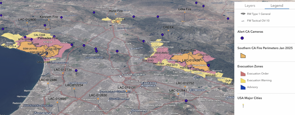
Below we reprint the relevant evacuation-order maps and indices for neighborhoods impacted by the Palisades and Eaton fires, as of Jan. 10, 2025 (at 2am Pacific). Note that the fires and threat of fire in areas highlighted in pink amount to an “immediate threat to life.” Persons there are under a “lawful order to LEAVE NOW.”
In turn, fire in or near areas highlighted in yellow constitute a “[p]otential threat to life and/or property [so those requiring] additional time and those with pets and livestock should leave now.”
Eaton Fire Region: La Canada Flintridge, Altadena, Pasadena, Sierra Madre, Monrovia.

Eaton Fire Region: Evacuation Orders: Immediate threat to life.
This is a lawful order to LEAVE NOW The area north of Orange Grove/Rosemead Blvd., east of Lake Ave., and west of Michillinda Ave is lawfully closed to public access.
ALD-ARROYOSECO, ALD-CALAVERAS, ALD-CANON, ALD-CASITAS, ALD-CHANEY, ALD-EASTLOMA, ALD-EATONCANYON, ALD-FARNSWORTH, ALD-GARDEN, ALD-GARFIAS, ALD-LAUREL, ALD-MEADOWS, ALD-MENDOCINO, ALD-MIDLOTHIAN, ALD-MILLARD, ALD-MOUNTLOWE, ALD-PALM, ALD-RUBIO, ALD-WAPELLO, ALD-WHITEPARK, ARC-001, ARC-002, ARC-004, GLN-E018, GLN-E027, GLN-E028, GLN-E029, GLN-E030, GLN-E039, GLN-E040, GLN-E041,GLN-E043, GLN-E044, KIN-KINNELOA, LAC-E165-B, LAC-E167, LAC-E168-A, LAC-E183, LCF-ALTACANYADA, LCF-BERKSHIRE, LCF-CASTLE, LCF-CIVICCENTER, LCF-COMMONWEALTH, LCF-CREST, LCF-CROWN, LCF-DESCANSO, LCF-FOOTHILLEAST, LCF-FOOTHILLWEST, LCF-HAMPSTEAD, LCF-HILLARD, LCF-INVERNESS, LCF-JPL, LCF-MEMORIAL, LCF-PARADISE, LCF-STARLIGHT, MRV-101, MRV-102, MRV-201, MRV-202, MRV-203, MRV-204, PAS-E001, PAS-E002, PAS-E003, PAS-E006, PAS-E008, PAS-E010, PAS-E012, PAS-E019, PAS-E022, SMD-E001, SMD-E002, SMD-E003, SMD-E004, SMD-E005, SMD-E006, SMD-E007, SMD-E008, SMD-E009, SMD-E010, SMD-E011, SMD-E012, SMD-E013, SMD-
Evacuation Warnings: Potential threat to life and/or property.
Those who require additional time to evacuate, and those with pets and livestock should leave now.
ARC-003, ARC-005, BRA-001, BRA-002, BRA-003, BRA-004, CRV-ALABAMA, CRV-BRIGGSTERRACE, CRV-COMMUNITY, CRV-HENRIETTA, CRV-MONTROSE, CRV-MOUNTAIN, CRV-PINECONE, CRV-TEASLEY, DUA-001, DUA-002, DUA-005, DUA-008, GLN-E001, GLN-E002, GLN-E003, GLN-E004, GLN-E006, GLN-E013, GLN-E017, GLN-E026, GLN-E038, MRV-301, MRV-302, MRV-303, MRV-304, MRV-305, MRV-401, MRV-402, MRV-403, MRV-404, PAS-E004, PAS-E005, PAS-E007, PAS-E009, PAS-E011, PAS-E013, PAS-E014, PAS-E015, PAS-E016, PAS-E017, PAS-E018, PAS-E020, SMD-E018 For the latest update, including as to evacuation orders, evacuation warnings, road closures, school closures, and evacuation shelters for humans and animals,, click here.
Palisades Fire Region: Including coastal areas east of Malibu and west of Santa Monica
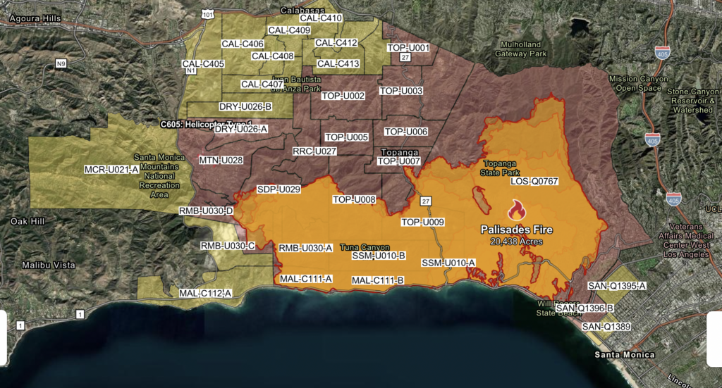
Evacuation Orders: Immediate threat to life.
“This is a lawful order to LEAVE NOW. The area is lawfully closed to public access. Evacuation Orders are in effect for the following zones:
DRY-U026-A, LOS-Q0767, MAL-C111-A, MAL-C111-B, MAL-C112-B, MTN-U028, RMB-U030-A, RMB-U030-B, RMB-U030-D, RRC-U027, SAN-Q1395-B, SAN-Q1396-B, SDP-U029, SSM-U010-A, SSM-U010-B, TOP-U001, TOP-U002, TOP-U003, TOP-U004, TOP-U005, TOP-U006, TOP-U007, TOP-U008, TOP-U009
Evacuation Warnings: Potential threat to life and/or property.
Those who require additional time to evacuate, and those with pets and livestock should leave now.
“Evacuation Warnings are in effect for the following zones:
CAL-C405, CAL-C406, CAL-C407, CAL-C408, CAL-C409, CAL-C410, CAL-C411, CAL-C412, CAL-C413, CAL-C414, CAL-C415, DRY-U026, DRY-U026-B, MAL-C112, MAL-C112-A, MCR-U021-A, RMB-U030-C, SAN-Q1395-A, SAN-Q1396-A, SAN-Q1388-C, SAN-Q1389.”
For the latest update, including as to evacuation orders, evacuation warnings, road closures, school closures, and evacuation shelters for humans and animals, click here.
By the numbers:
The Eaton fire, at nearly 14,000 acres (and counting) now directly impacts an area whose resident population is nearly 103,000 persons, at least 20% of whom are age 65 years and up.
According to CalFire:
“Red Flag high wind conditions are expected to continue until Thursday evening. The combination of low humidity, dry fuels, and shifting winds has heightened the potential for spot fires and rapid expansion. Residents are urged to remain alert and follow instructions from local authorities as the situation evolves.”
To date, again according to CalFire, there are two fatalities from the Eaton Fire — and 4,000 structures have been destroyed.
Special note: “Debris and elevated turbidity from the Eaton Fire potentially impacted Pasadena Water and Power’s (PWP) drinking water system in the Eaton Fire evacuated areas. The State Water Resources Control Board, Pasadena Public Health Department, and Pasadena Water and Power Water System are advising residents of Pasadena to NOT USE THE TAP WATER FOR DRINKING AND COOKING IN THE IMPACTED AREAS UNTIL FURTHER NOTICE.”
The Palisades fire may be “the costliest on record, period.”2According to a CNN interview of UCLA climate expert Daniel Swain. CNN observes that, “so far, the 2018 Camp Fire, which decimated the isolated foothill town of Paradise in Northern California, has been the costliest wildfire disaster in US history, burning more structures than the next seven most destructive fires in state history combined. [But, according to CNN] “Swain said the conditions leading up to both events — the 2018 Camp Fire and the fires currently raging across Los Angeles County — essentially show “the same story.” Highly flammable grass and shrubs, in concert with strong winds and record-high temperatures and dry conditions — the kind of extreme weather often exacerbated by climate change — primed the environment for catastrophic wildfires.” Swain, incidentally, was an expert witness at CPR Initiative’s August 7, 2024 public hearing, held in Hayward, California. The hearing was our fourth in a series to examine the question, “What More Should the United States Do On Climate?“ According to CalFire, it has already consumed more than 20,000 acres (and counting) now directly impacts an area whose resident population is nearly 44,000 people, more than a quarter of whom are age 65 and up.
According to CalFire:
“The Palisades Fire continues to exhibit wind-driven and topographic runs upslope. Short-range spotting is still observed. Gusts up to 40 mph were observed into Thursday afternoon. North to northeast winds are expected to increase with poor overnight humidity recovery.
“On Saturday, typical mid-January conditions are expected. Sunday and continuing through the middle of next week, weak to moderate Santa Ana winds are expected. There is a chance of strong winds Tuesday. There will continue to be a high likelihood of critical fire weather conditions through next week.
“The Los Angeles County and CAL FIRE Damage Assessment Teams (DINS) continues to assess and validate structures impacted by the Palisades Fire. More than 5,000 structures have been destroyed.
“The Los Angeles Unified School District has canceled classes for all schools Friday. Residents are encouraged to avoid nonessential travel to allow firefighters plenty of room to work.”
Source: Airbus, USGS, NGA, NASA ,CGIAR, NLS, OS, NMA, Geodatastyrelsen, GSA, GSI and the GIS User Community
Pasadena Rainfall: Recent Months
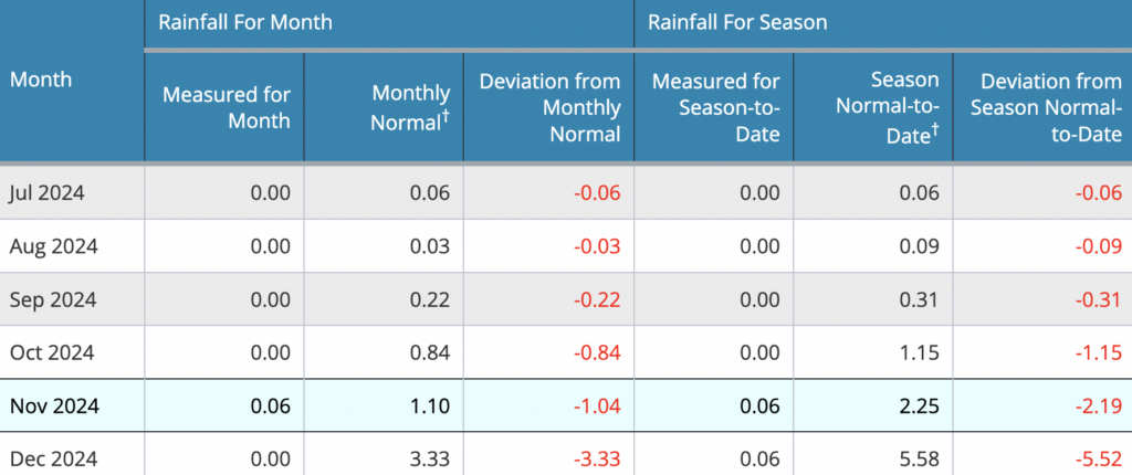
I cannot remember when it last rained here.
Editor’s Note: In compliance with local orders, Climate Protection & Restoration Initiative volunteer Terra Mahadevan evacuated from her Pasadena home yesterday. She writes from a hotel room, where she, her school-age children, and her husband shelter and wait out the Eaton Fire.
On the morning of January 8th, we received evacuation orders to leave our home in Northwest Pasadena.
Our house is mere blocks away from Altadena — the unincorporated city whose name means “Upper Dena,” where eventually, the tree-lined neighborhoods of historic homes, small family-owned businesses and hiking trails would become devastated and reduced to rubble as a result of the Eaton Fire.
Ash poured from the sky and the violent wind whipped the branches of our oak trees as we loaded into our car and headed south.
The combination of the Santa Ana wind storm starting earlier in the day, rattling the region with 80mph + winds, and bone dry conditions on the San Gabriel foothills, the perfect condition for a wildfire that would be impossible to contain were created.
The last couple of winters have been wet and rainy, so much so that I begrudgingly bought my Southern California-raised daughters rain boots that lined up like bright soldiers on our back porch from December to March.
But this winter has been different: dry and cold mornings faded into 65 degree days, with no significant rain. Indeed, I cannot remember our last rain. The sun has shined unrelentingly most days, and I found myself yearning for the rainy winter days that promised abundance and growth come spring.
My heart is broken for our community and beautiful foothills. Many businesses that make our city vibrant and special, leveled. Homes and schools, gone. The hopes, dreams and livelihood of many devastated. Our beautiful foothills burnt to a crisp. Despite the utter heartbreak and loss, I have witnessed small acts of kindness and generosity that gives me glimmers of hope for our community.
— Terra Mahadevan
Footnotes:
- 1Regrettably, at 4pm pacific yesterday, January 9, an evacuation order earmarked for Hidden Hills residents near the Kenneth Fire (just north of the 101) was mistakenly sent to residents all across Los Angeles County. But the overwhelming majority of evacuation orders that have been issued across the county have been accurate and life-saving.
- 2According to a CNN interview of UCLA climate expert Daniel Swain. CNN observes that, “so far, the 2018 Camp Fire, which decimated the isolated foothill town of Paradise in Northern California, has been the costliest wildfire disaster in US history, burning more structures than the next seven most destructive fires in state history combined. [But, according to CNN] “Swain said the conditions leading up to both events — the 2018 Camp Fire and the fires currently raging across Los Angeles County — essentially show “the same story.” Highly flammable grass and shrubs, in concert with strong winds and record-high temperatures and dry conditions — the kind of extreme weather often exacerbated by climate change — primed the environment for catastrophic wildfires.” Swain, incidentally, was an expert witness at CPR Initiative’s August 7, 2024 public hearing, held in Hayward, California. The hearing was our fourth in a series to examine the question, “What More Should the United States Do On Climate?“


